SIGN UP FOR MY EMAIL TO RECEIVE YOUR FREE SAN FRANCISCO PLANNING GUIDE.
- Home
- Attractions
- Twin Peaks
Twin Peaks San Francisco: Amazing Views All Around SF & the Bay Area
By: Jill Loeffler • Updated: January 13, 2025
Head to the top of Twin Peaks San Francisco for some of the best views of SF and the entire Bay Area.
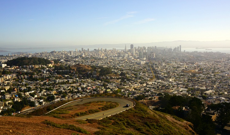
At more than 900 feet above sea level, these two hills offer views of the Golden Gate Bridge, Alcatraz, downtown SF, Angel Island, and so much more.
Read on for tips on how to get here, hikes around the area, maps, parking, tours, and everything else you will need to visit.
I've also included some tips for those that want to visit at night.
As of January 2025, they are in the process of improving the trails here. The work is almost done, but during my last visit on January 4, there was still some equipment around. It shouldn't impact your visit too much, but just be aware that they are in the process of improving the experience (and safety) of visitors!
It's a must see on your stay in the SF Bay Area!
SFTourismTips is made possible by readers like you! If you book through my links, I may earn a small commission at no extra cost to you. Thanks for your support! Learn more.
Twin Peaks Summit Information & Other Fun Facts
The second highest natural point in the city, Twin Peaks is popular due to its central location and unobstructed views all around the SF Bay.
It's part of a 64-acre Twin Peaks Natural Area and is free to visit 365 days a year.
Twin Peaks San Francisco is accessible for everyone, whether you hike up, drive up, or climb further up from the parking lot.
With no trees or buildings in the way, you get 360-degree views from its summits, and even if you only get out at the north-facing parking lot, it still offers an incredible vantage point of SF's treasures.
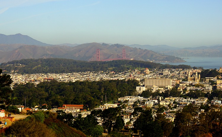
In the photo below from my last visit, you can see the Golden Gate Bridge and in the background.
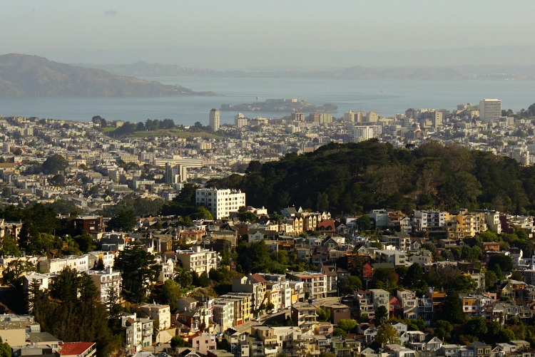
Alcatraz Island is also visible from the summit as you look out toward the bay.
Fun Facts
- Twin Peaks is included in the original "Seven Hills of San Francisco," though the city has 43 named hills in total.
- At 922 feet each, the peaks are the second tallest natural points in SF after the 928-foot-tall Mount Davidson, whose extra 6 feet of elevation are covered with trees and therefore do not offer the same 360-degree views.
- Of the two peaks, the northern one is called "Eureka" and the southern one is called "Noe."
- Christmas Tree Point is a third summit here. It isn't as high as the two main peaks but is on the northern side of the park and offers great views of downtown, the Golden Gate Bridge, and Alcatraz Island. It's also where you will find the main parking lot.
- After the city released 22 endangered mission blue butterflies here in 2009, Twin Peaks has become one of the only places in the area where this species thrives. Be on the lookout for them during your visit and make sure to check out the newly updated trail that takes you close to their habitat.
- This is one of the stops on the famous 49-Mile Scenic Drive around SF.
Preparing for the Weather at Twin Peaks San Francisco
If you plan to visit Twin Peaks San Francisco, you will want to be dressed accordingly. Due to its height, there is usually more wind up here and a temperature drop of a few degrees at its summits.
Make sure to bring along a light jacket or windbreaker to stay warm and enjoy the views comfortably.
In the summer, the peaks are often a natural barrier for the ocean fog that rolls in, so you will find more fog as you face west and clearer skies as you face east.
During the winter, it can be drizzly and cold, so it's a good idea to bring an umbrella that does well in the wind.
You will also find that the trails can get a little muddy during our rainy season (November - March), so make sure to wear shoes that you don't mind getting a bit dirty during this time of year.
Here are more tips on what to expect from the weather here each month of the year.
More Tips to Visit
Twin Peaks San Francisco is free to visit, and open every day of the year from 5am to midnight.
You can get here by car, on foot, by public transit, or on a tour. See the sections below for more details on each of these options. Here are just a few other tips for visiting.
- Visit Length: Most people spend between 30 minutes and an hour during their visit.
- Comfy Shoes: If you plan to hike up to the summit or around this area, make sure to wear comfortable shoes. The stairs are steep and can be uneven in places. Even though they are well maintained, it's best to wear flat soled shoes that will allow you to walk around easier.
- Eastern Loop Closed: One of my favorite changes to this popular SF attraction is that they have closed off part of the road to make it safer for pedestrians. You can now walk from one summit to the next without having to wait or watch out for cars. The area that's now closed to car traffic is the eastern loop of the figure 8 at the top.
- No Other Services: You will not find any other services here such as hotels, restaurants, or activities. The draw here is the view!
Twin Peaks San Francisco at Night
One of the best features of this viewpoint attraction is that you can visit any night of the year before midnight to get those amazing sunset photos or take in the dazzling city lights.
If you plan to visit after the sun goes down, I recommend driving and parking in the northern parking lot instead of hiking to the top.
The area is safe, but this way you won't have to worry about the visibility of the trails and you'll still get a great view.
>> More fun things to do at night in SF
Twin Peaks Address, Parking, Directions and Map
The official address is 501 Twin Peaks Blvd San Francisco, CA 94114.
It's in the heart of the city and easy to find with Sutro Tower (red and white tower) that stands high above the peaks.
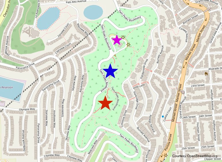
Here is a map of the 31-acre area. The blue star shows the northern summit and the red star shows the southern summit.
The smaller purple star is the main parking lot.
Parking
You will find a parking lot on the northern side of the summits. The parking lot is small (less than 30 spots total with a couple of handicap spots), so you might have to wait in your car for up to 30 minutes before a spot opens.
If you are up for a hike to the top, you have a few additional parking options at the base. In the section below, I've outlined the trail details from these locations.
Directions
Right now, the gate leading to the parking lot through Burnett Avenue is closed and is for pedestrians only.
If you are driving, you will need to enter through Portola Drive to get to the main parking lot here.
Tips to Hike
Twin Peaks San Francisco offers the unique chance to hike without leaving the city. The trails here are not long, but you will get a great workout as they are steep.
The main hike up and down both summits is around 0.7 miles one way.
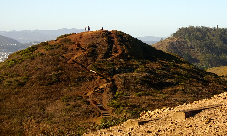
Here is a picture of the trail I took to the top of one of the summits. The other is similar with mostly steps to the top.
You can extend your hike by parking in the neighborhood at the base and taking one of two main trails up to the peaks.
I usually start at Crestline Drive, where there is plenty of parking and also where the 37 Corbett bus stop is located (see section below for tips to take the bus to this trailhead).
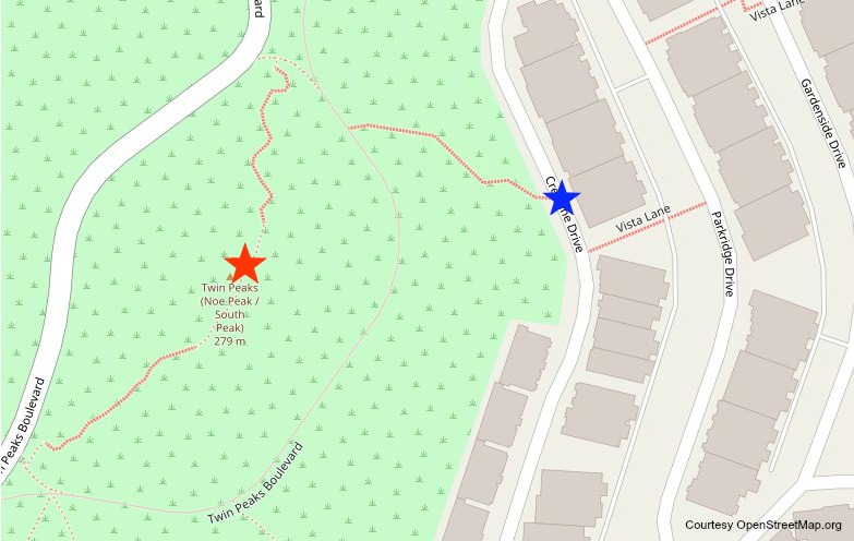
From there, you will climb up the eastern side of the hill and then make your way to the summits. This trail is not much longer, but it's steep and it will get your heart pumping.
Here is a map to show you where to find this trailhead to the top. The blue star shows the trailhead; the red star shows the southern summit.
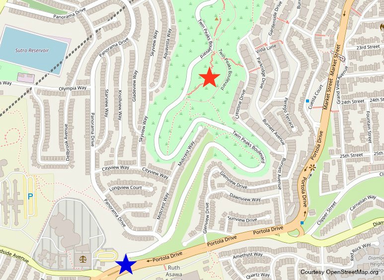
There is another trail that comes in from the south. It starts near Portola Drive and Twin Peaks Boulevard. I recommend parking on Twin Peaks Boulevard or in the neighborhood on either Panorama Drive or Midcrest Way and walking over to the trailhead.
You can also take the bus to this trailhead (36 or 44 from the Forest Hill Station—see my write up below for details on how to get here by bus).
You will find the trail on the other side of the silver railing along Twin Peaks Boulevard (on your right as you face up hill toward the summits).
This one is longer than the Crestline trail (about 1.5 miles one-way), but does not start out as steep.
In the map below, the blue star indicates the trailhead and the red the southern summit.
The city is continually making improvements to the trails here, including updating the staircases as well as a trail that will get you closer to the mission blue butterfly habitat.
More Twin Peaks San Francisco Tours
Below you'll find my top picks for bus and city tours that visit Twin Peaks.
San Francisco City Tour
This 3.5-hour tour offers you the chance to see the summit of Twin Peaks San Francisco (weather permitting) as well as several other top attractions in SF.
You will also see the Golden Gate Bridge, the Alamo Square Painted Ladies, and the Opera House in the Civic Center District.
As you ride around on this comfy bus, you will also learn about the history of SF, fun facts about each attraction, and a few hidden gems.
>> Visit GetYourGuide for ticketing information
San Francisco Luxury Van Tour with Snacks
This 4 hour tour includes a chance to see Twin Peaks, Fort Point and the Golden Gate Bridge. You will also learn more about our other top attractions as you cruise around SF on this comfortable van.
Complimentary snacks and water are also available. This smaller group tour allows you to see more of the local sights that larger buses are not able to visit!
How to Get to Twin Peaks Without a Car
In addition to the Twin Peaks San Francisco tours, you can also get here on public transit.
It does take a little more hiking to get to the top, but it's a fun way to visit.
You can also visit by using Lyft or Uber.
Public Transportation
You have a few options to get here on public transit.
None of them will take you to the top, but instead will take you to the trailheads where you can then climb the trails to get here.
37 Corbett from the Castro
This bus has a short route that will take you within a couple of blocks of the eastern trailhead. The stop I usually use is the one at Parkridge and Crestline. From here, head over to Crestline Drive and find the stairs leading up to the trail.
When you get on the bus, you can also ask the bus driver to tell you which one is your stop. They are often friendly and are happy to help.
To catch this bus, take public transit to the Castro Street Station and then transfer to the 37.
- F Streetcar: This will take you from Fisherman's Wharf all the way to the Castro. It's a slow ride, but a fun way to see quite a bit of the city.
- K, L, & M: All three of these Muni trains will also take you to the Castro Street Station where you can then transfer to the 37 Corbett bus.
36 from Forest Hill Station
A second option is to stay on the K, L, or M train to the Forest Hill Station, where you can then transfer to the 36. Take them just under a mile to the Marview Way and Panorama Drive stop.
From here, you would walk up Marview Way and then take a right at the trail that starts to head up to Twin Peaks. You will find it just across from Fairview Court.
You'll walk on this trail until you reach Twin Peaks Blvd (which currently is closed to cars) and then take a right to start climbing this street up to Twin Peaks.
Lyft or Uber
If you don't want to climb to the top, but also don't want to rent a car, consider using Lyft or Uber.
To cut down on the cost, first take the Muni to the Castro Street or Forest Hill Station, and then contact them from here.
It's then an easy walk down with gorgeous views, or you can call a Lyft or Uber to pick you up when you are ready to leave.

Hi, I’m Jill!
I’ve been sharing San Francisco travel advice since 2009 and have helped millions of people explore the city like a local. Whether you’re dreaming of sea lions, cable cars, or a great sourdough bread bowl, I’m here to help you plan an unforgettable trip with real tips from someone who actually lives here.
Comments? Questions? Suggestions?
I would love for you to join me in my private Facebook group!
It's a great place to interact with me and others who are familiar with the area.
You can ask questions, get advice for your upcoming stay, and then share your photos and advice with others when you return home. It's a great community and the fastest way to get answers to those nagging questions about your visit!
